Tropical Depression Forming, Could Become Typhoon 熱帶低壓生成 有機會發展為第9颱"盧碧"

加入公視會員,
按讚收藏你關注的報導
Taiwan could see another typhoon shortly. A tropical depression is currently forming over the South China Sea, and could become the ninth typhoon of the current season. Meteorologists say that it could make landfall, but further observation is needed on its path.
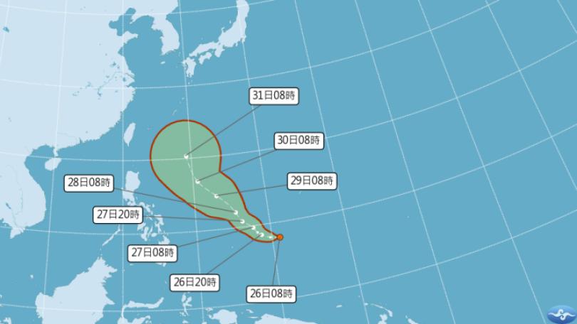
A tropical system is currently forming off the coast of Guangdong and became Tropical Depression 11 on Aug. 3. It has the potential to become the ninth typhoon of the current season, Lupit. The Central Weather Bureau says that regardless of whether it becomes a typhoon, all predictions of its path show that it will have the biggest impact on Taiwan from Aug. 5 to 7.
Wu Wan-hua, Senior Specialist, Central Weather Bureau:"Between today and tomorrow, which are Tuesday and Wednesday, it could strengthen into a mild typhoon and then travel in a northeasterly direction to approach the Taiwan Strait. Based on our forecast, it could affect our sea between Thursday and Saturday."
Taiwan will feel the effects of the depression and southwest monsoon on Aug. 3 and 4, and various areas could see heavy rain. Chiayi's Xingang Township has seen an accumulated rainfall of over 300 millimeters during the past two days, while the accumulated rainfall in Pingtung's Chunri Township surpassed 280 millimeters. Experts say the rain will continue in the south and central region. Starting on Aug. 5, the tropical depression or typhoon will intensify the rain and the typhoon may make landfall.
Peng Chi-ming, CEO, WeatherRisk Explore Inc.:"It will approach Taiwan on Thursday and Friday, and there is the possibility that it will make landfall. However, there are many variables in play. Another thing is that this monsoon depression will slowly head north during the weekend. There will still be a southwest monsoon environment next Monday and Tuesday."
Experts say Taiwan is located in a low-pressure zone, and if a low-pressure system to the northeast continues to develop, the mutual traction will be more complicated. The path of the tropical depression should be clearer by Aug. 4, and the public needs to stay vigilant.
位廣東沿海的熱帶擾動,週二上午已發展為"熱帶性低氣壓" TD11,有機會發展為今年第9號颱風"盧碧",氣象局提醒,無論是否成颱,綜合各國路徑顯示,週四到週六,將是影響台灣最明顯時候 !
中央氣象局簡任技正 伍婉華表示:「她在今天到明天兩天,星期二到星期三兩天,有機會增強為輕度颱風,之後再向東由偏北的方向,接近台灣海峽,如果如我們預報的資料來看的話,她在星期四到星期六,可能會影響我們的海面。」
週二週三,台灣持續受低壓帶及西南風影響,各地仍有強降雨,其中嘉義新港兩天以來,累積降雨量已經突破300毫米,屏東春日累積降雨量,也超過280毫米,氣象專家提醒,中南部降雨將持續,尤其週四開始,熱帶性低氣壓或颱風影響,雨勢將加劇,甚至颱風不排除登陸可能 !
天氣風險公司總經理 彭啟明表示:「禮拜四、禮拜五的時候,是滿接近台灣,不排除會登陸的可能性,但是這個變數很高。那另外一個就是,當這個季風低壓,大概到週末的時候,會慢慢北抬,下禮拜大概一、二,還是西南風的環境。」
專家分析,因台灣位處在大低壓帶內,若台灣東北邊的低壓持續發展,互相牽引就會比較複雜,預計在週三,熱帶性低氣壓的路徑會比較明朗,民眾要持續留意預報資訊。