Ferry Service Suspended with Hagupit Approaching|哈格比增強 取消台東往返蘭嶼.綠島船班

加入公視會員,
按讚收藏你關注的報導
發布時間:
更新時間:
In the face of severe tropical storm Hagupit, the Central Weather Bureau has issued a series of sea typhoon warnings. Meanwhile, all ferries between Taitung and Green Island and Taitung and Orchid Island were canceled, leaving over 6,000 tourists stranded.
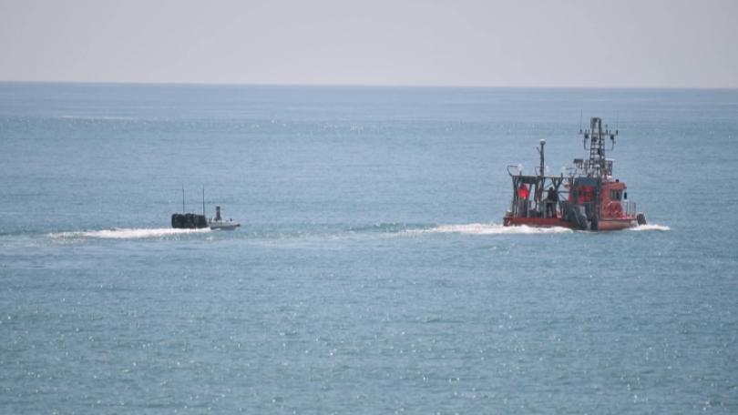
Although rain wasn't hitting Green Island just yet on the morning of the 3rd, winds grew stronger throughout the morning. With ferry service suspended for the day, 4,863 tourists were stranded on Green Island and 1,632 on Orchid Island.
It is very windy in Green Island today and boats aren't able to leave or enter the dock. As a result, ferry service has been suspended for the day. Tourists may have to wait until tomorrow to leave.
The Central Weather Bureau issued sea typhoon warnings in the morning as severe tropical storm Hagupit got closer to Taiwan. As of 11:30 a.m., Hagupit's center was located 150 kilometers east-northeast of Keelung and moving north-northwest. Its storm circle crossed over northeastern Taiwan before noon, causing long waves off of Taiwan's northern, eastern, and southern coasts as well as off of Penghu and Matsu. Category-9 winds were also reported in areas north of Taoyuan and some of Taiwan's offshore islands. The bureau is warning everyone to take flood prevention measures.
Based on our forecasts, Hagupit's storm circle will leave Taiwan proper this evening. At present, northern Taiwan is still receiving a lot of rain from the storm.
The bureau says it will issue typhoon warnings if they becomes necessary. Northern Taiwan will see short showers, and western and southern Taiwan could as well. Farmers in eastern and southern Taiwan, meanwhile, should be on guard for Foehn winds.
一大早的綠島,還沒下大雨,還隱約可見藍天,不過手機拍下的畫面,可明顯聽到風聲呼嘯,路上遊客零星外出,受到輕度颱風哈格比外圍環流影響,今天(8/3)往返綠島與蘭嶼的船班,以及後壁湖往返蘭嶼的船班,全天取消,造成旅客滯留綠島有4863人,滯留蘭嶼1632人,共超過六千人。
「綠島今天的風很大,港口那邊船隻無法進出,所以今天船隻全部停航,要來綠島的旅客,可能要改搭明天的船,看明天的天氣而定。」
哈格比颱風白天最接近台灣,氣象局持續發布海上颱風警報,上午11點半,它的中心位置,位於基隆的東北東方、約150公里之海面上,向西北轉北北西移動,它的暴風圈上午已經進入台灣東北部及北部海面,東半部、基隆北海岸、恆春半島與澎湖馬祖,都有長浪發生,桃園以北與部分外島,會出現九級左右強陣風,氣象局提醒各地要嚴防大雨。
中央氣象局預報員 謝佩芸表示:「我們預期今天在傍晚後,哈格比颱風它的暴風圈,就會逐漸遠離台灣本島,台灣現在在北部,比較北台灣的區域,是持續受到颱風外圍環流影響,有比較明顯的降雨。」
是否有可能針對哈格比發布陸上颱風警報?氣象局表示,預估還是以海警為主,但會根據最新監測狀況,對外說明。另外,北台灣會陸續出現短暫驟雨,西南部海面則受到雲系移進影響,也可能出現短時間強降雨。東南部的話,則要注意會有焚風出現,提醒農民注意。