Lupit Weakening, Land Warning Not Expected: CWB 氣象局估盧碧強度將減弱 陸警機率降低
加入公視會員,
按讚收藏你關注的報導
Tropical Storm Lupit is making its way towards China and weakening, While the Central Weather Bureau says the chances of a land warning are low, heavy rain is still expected in some parts of Taiwan.
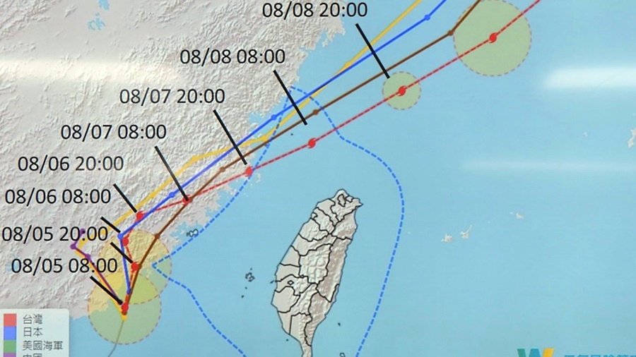
As of noon on Aug. 5, Tropical Storm Lupit was 220 kilometers southwest of Kinmen and moving northwest at a speed of five kilometers per hour. It is expected to make landfall in Guangdong later in the afternoon.
As Lupit is weakening, the chances of a land warning being issued on Taiwan's offshore islands have gone down.
Luo Ya-yin, Senior specialist, Central Weather Bureau:"After (Lupit) makes landfall in Guangdong, it will weaken on Aug. 5 to 6 as it slowly moves towards Fujian. On Aug. 7, it will start approaching Matsu and after Aug. 8 it will be off Taiwan's northern coast."
The Central Weather Bureau says Lupit may be downgraded to a tropical depression and it will be closest to Taiwan from Aug. 5 to 7. Experts say Kinmen and Matsu should be prepared for short bursts of heavy rain, along with mountainous areas in central and southern Taiwan. The bureau has issued heavy and extremely heavy rain advisories for five municipalities in southern Taiwan.
Peng Chi-ming, CEO, WeatherRisk:"(Lupit) will bring strong rain similar to rain from the southwest current, and mountainous areas in central and southern Taiwan, including Kaohsiung, Pingtung, and Chiayi, should be prepared for torrential rain."
Meanwhile, meteorologists are monitoring a tropical depression currently off the coast of the Ryukyu Islands. They say the depression may have a chance of developing into the 10th tropical storm of the season but is unlikely to affect Taiwan.
從氣象局的天氣預報圖可清楚看到,輕度颱風盧碧目前的中心位置在金門的西南方約 220 公里之海面上,以每小時8轉5公里緩慢速度,向北北東轉北北西進行,暴風圈已進入臺灣海峽,對臺灣海峽構成威脅,午後朝中國廣東一帶登陸,盧碧強度也會逐漸減弱,離島發布陸警機會也降低。
氣象局技正 羅雅尹表示:「預計它(盧碧)逐漸進入廣東之後,由於導引氣流稍微減弱,所以接下來1到2天,移動的速度會稍微慢一些。5號、6號大致上,是在廣東到福建這一帶緩慢的移動,7號逐漸往東北接近馬祖地區,8號之後會進入台灣的北部海面。」
氣象局表示,受到地形破壞後,盧碧有機會減弱為熱帶性低氣壓,但週四開始到週六仍是最接近台灣的時間,金門、馬祖首當其衝,而氣象專家則說,接下來3天仍要留意颱風外圍環流,加上西南季風,將會讓中南部容易有短延時強降雨,尤其山區的降雨會更明顯,氣象局也在稍早對南台灣5縣市發布豪雨、大雨特報。
天氣風險公司總經理 彭啟明表示:「它(盧碧)有些雨帶,是類似這種西南氣流,可能是比較強的西南風這樣的雨勢,所以對中、南部,尤其是高雄、屏東的山區,甚至中部包含了嘉義的山區,都要特別留意,有可能會發生局部豪雨的事件會發生。」
至於目前在琉球群島南方的熱帶性低氣壓,氣象局說,將有機會在這兩天發展成為今年第十號颱風銀河,會往日本南方前進,對台灣無直接影響。