CSRSR Releases Calendar Featuring Impressive Satellite Images of Taiwan 中央大學衛星影像月曆 經典電影場景入鏡

加入公視會員,
按讚收藏你關注的報導
The beauty of Taiwan has been presented from a different angle in the 2022 calendar published by the Center for Space and Remote Sensing Research at the National Central University. Some iconic filming locations of Taiwan's classic movies were captured from above, by above I mean satellites in outer space, and turned into very-high-resolution optical images.
Liang Hsiu-shen, Director: “We walked every day for over three hours from Taiping Mountain Villa to Cueifong Lake to film the movie.”
Famous actor and director Liang Hsiu-Shen searched through nostalgic memories of shooting for the 1979 Taiwanese movie "Chun Han" filmed in the Taiping Mountain area.
Liang Hsiu-shen, Director: “We left before daybreak, and we usually return after 3 p.m., or else it gets all dark really soon. The scenery was beautiful and serves as the backdrop for a story about a girl and a boy growing up as childhood sweethearts and they developed a deep friendship and love for each other. It was touching.”
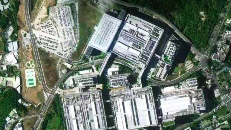
These are satellite images of Taiping Mountain in Yilan, and Jiufen in northeastern Taiwan, where another classic 1986 Taiwanese movie "Dust in the Wind" was filmed. Satellite images of Xianxi Township in Changhua County, where the classic 1965 Taiwanese movie "Beautiful Duckling" was filmed are also captured. The Center for Space and Remote Sensing Research under National Central University has released its 2022 calendar featuring satellite images of filming locations for movies in Taiwan. Pléiades satellite constellation was used, providing very high-resolution optical imagery that delivers 50-centimeter imagery with a 20-kilometer swath. The extremely high level of detail fully captures the beauty of Taiwan from above.
Tsai Fu-an, Research professor, CSRSR, National Central University: “By capturing images from different perspectives and angles, we can determine the specific coordinates. You see, in 1972, satellites could only offer 80m imagery, now it has powered up to 50cm imagery. Here used to be Haipu, a piece of reclaimed land on the coast of Changhua County. It turned into Changhua Coastal Industrial Park now.”
The Center for Space and Remote Sensing Research has started producing yearly calendars featuring satellite images under different topics since 1995 with 12 classic Taiwanese movies as this year's topic. Besides viewing Earth from a broader perspective, satellite images allow people to track how the area changed over time. They also help to detect and count a number of wildlife species in open and offer officials a wealth of information in analysis and monitoring of natural disasters such as hurricane and tornado damages from small to large regions around the globe.
導演梁修身說:「每天從太平山莊走了3個多小時到翠峰湖去拍攝。」
回顧40多年前,出演電影《春寒》的點點滴滴,導演梁修身,看著從衛星影像中所呈現的太平山景,心裡很有感。
梁修身表示:「(當時)我們天沒亮就走了,大概下午3點以後回頭了,不然就整個天黑了,風景優美在畫面裡面營造是兩個兩小無猜的情感,也格外動人。」
不只太平山,還有電影《戀戀風塵》的九份,以及《養鴨人家》的彰化線西地區,都被衛星完整拍攝。中央大學太空及遙測中心,推出2022年衛星影像月曆「遙電影」,經由能拍攝50公分級、超高解析影像的昴宿星地球觀測衛星(Pléiades),搭配3D測繪技術,為台灣各地留下紀錄。
中央大學太空及遙測研究中心教授蔡富安表示:「不同的視角及不同的角度,去拍攝同樣的一個地方,就可以去計算它精確的地表座標,(舉例)1972年拍攝的衛星影像,解析度只有80公尺,(今年)是50公分,當時拍攝養鴨人家的時候,這裡是海埔新生地,但是現在已經都變成現在的彰濱工業區了。」
太遙中心從1995年開始,每年都會以不同主題製作衛星影像月曆,這回挑選12部經典電影為主。從衛星影像中,還能從衛星解析度和地景風貌變化,來感受時代演進。相關技術,除了紀錄環境之外,對於生物群分布、天災的受災區域分析,都能提供協助。