Typhoon Hinnamnor Approaching Taiwan 軒嵐諾轉中颱持續靠近 發布海上警報
加入公視會員,
按讚收藏你關注的報導
A sea warning has been issued as Typhoon Hinnamnor is approaching Taiwan. The Central Weather Bureau called on boat operators to stay cautious while it hasn't ruled out the possibility of issuing a land warning, depending on its course on the 2nd and 3rd.
On the 2nd, the Central Weather Bureau issued a typhoon sea warning and called on all boat operators along the northern coast, southeastern coast and Bashi Channel to take precautions. Although Typhoon Hinnamnor has been downgraded to a medium storm, it could continue to strengthen as it moves north through a low pressure belt.
Lin Ping-yu, Central Weather Bureau Section Chief: “This typhoon's storm circle is expected to continue growing and it will start veering north (on the 3rd). At that time, its peripheral circulation will become more obvious. So, there will be a lot of rain, maybe even torrential rain, on (the 2nd and the 3rd).”
Torrential rain is expected from the afternoon of the 2nd to the afternoon of the 3rd. According to the bureau's 24-hour rain forecast, New Taipei City, Taoyuan City, Hsinchu County and mountainous areas could see 340 millimeters of rain. Low-lying areas could see 150-250 millimeters of rain, while mountainous parts of Yilan County and Taipei City could see 250 millimeters of rain. Heavy rain is also expected in Nantou's mountainous areas. The bureau says it may issue a land warning should the typhoon veer west as it heads north.
Peng Chi-ming, WeatherRisk CEO: “It is moving very slowly and it isn't moving in a straight path. Based on CWB tracking, a typhoon land warning could be issued late this evening. Its radius of maximum wind could make contact with Taiwan's northeastern corner.”
Experts say there will be heavy rain in northern and eastern Taiwan from the afternoon of the 2nd to the 3rd and everyone should watch out for flooding. Mountainous parts of central Taiwan may also see torrential rain, while areas north of Hsinchu and coastal areas may see strong winds. The impact of the typhoon on Taiwan should abate on the morning of the 4th. Everyone should stay away from mountainous and coastal areas until then.
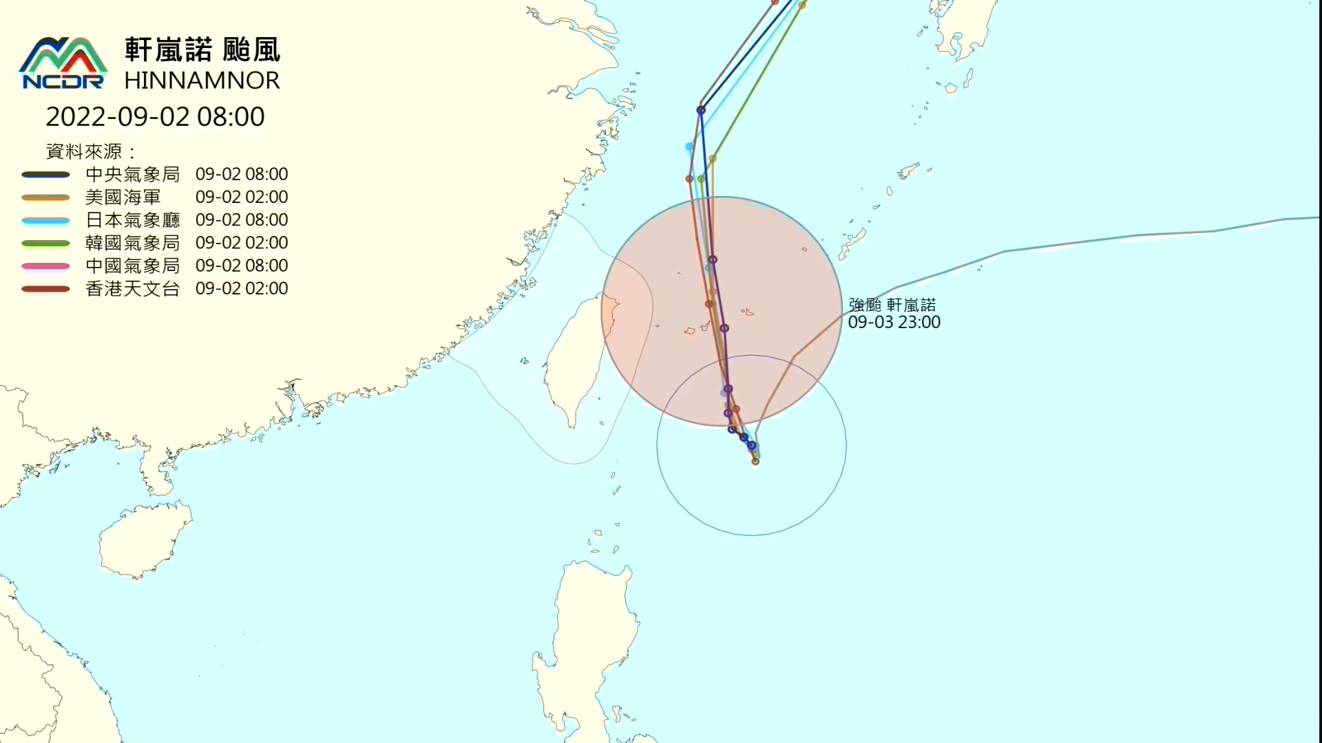
中颱軒嵐諾,中心位置在鵝鑾鼻的東方約 400 公里左右海面上,持續向西北轉北前進,暴風圈逐漸進入巴士海峽,氣象局在週五(2日)上午已經發布軒嵐諾颱風的海上颱風警報,提醒東北部海面,東南部海面和巴士海峽作業船隻,要嚴加戒備,而颱風雖然暫時減弱為中度颱風,但是在持續往北過程中,因為處在大低壓帶,強度可能再增強。
中央氣象局預報中心課長林秉煜表示:「我們預估這個颱風,未來它的暴風圈,還是有持續擴大的趨勢,颱風明天會再稍微持續北上一點點的時候,它的環流影響更明顯,所以你會看到今天、明天,這降雨比起來的話其實是相當的,甚至到明天整體的量級,累積有機會達到大豪雨的程度。」
週五下午開始,一直到週六(3日)下午,雨勢會越來越明顯,根據氣象局發布的24小時雨量預測,新北市、桃園市、新竹縣山區累積總雨量,有機會來到340毫米,平地也有150到250毫米的降雨量,宜蘭縣和台北市的山區降雨也上看250毫米,南投山區也要嚴防雨勢。氣象專家分析軒嵐諾在往北走的過程中,因缺乏導引呈現左右搖晃的路徑趨勢,若是路徑再往西偏一點,就可能會發布陸上颱風警報。
天氣風險公司總經理彭啟明指出:「它的速度非常地慢,而且還有一點扭扭捏捏,最主要它本來就是一個溜底在打轉,按照目前氣象局路徑的趨勢的話,應該最快的話今天晚上深夜,可能就會發布陸上颱風警報,因為它的外圍暴風半徑,恐怕會碰觸到我們的東北角的陸地。」
專家提醒,週五下半天起一直到周六,在北部、東北部降雨最劇烈,要留意累積雨量可能帶來的災害,另外是中部山區,也可能會有局部豪雨的機會,新竹以北以及各地沿海的陣風都會「很有感」,颱風預計在周日(4日)上半天逐漸遠離,提醒民眾在周末,要避免前往山區與海邊活動。