COLLIDING WEATHER SYSTEMS BRING HEAVY RAIN, SET TO CONTINUE|梅雨鋒面+西南氣流 雙北.基隆強降雨
加入公視會員,
按讚收藏你關注的報導
發布時間:
更新時間:
A combination of the rainy season front and a south-west monsoon weather system affected the northern coast, Keelung, New Taipei City and Taipei City with extremely torrential rain. Heavy rain started before dawn yesterday. Sanzhi and the Fugui Cape had over 600 mm of rain. The Central Weather Bureau said that a period of intense convection caused heavy rain, and the rain was moving gradually south from Taipei, Taoyuan and Hsinchu, down to Miaoli, Taichung and Nantou. There will be sustained heavy rainfall, and by strong gusts of wind, and the public should be vigilant.
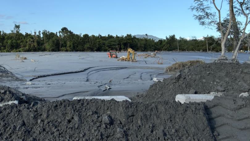
Torrential rain substantially lowers visibility between vehicles on the road making for dangerous driving conditions. Strong convection from the seasonal rainy front and a south-west monsoon weather system brought heavy rain before dawn yesterday. This gradually expanded southward with Taoyuan and Hsinchu experiencing heavy rainfall, and by early morning the cumulative rainfall in Keelung and the north coast was amazing. Up until 4 pm yesterday, New Taipei's Sanzhi and Fugui Cape had over 600 mm of rainfall. Jinshan and Wanli had almost 600 mm and Danshui and Keelung had almost 400 mm. The Central Weather Bureau estimated that from June 2 to 3, level ground in the north central and southern regions would have at least 300 mm and 500 mm in mountain regions, and eastern mountain regions would have around 300 mm of rainfall.
==CHEN YI-LIANG Dep-Dir., CWB Forcast Center==
We especially want to remind those in certain localities in the western region and the northeast region and Hualien-Taitung mountain regions, that over the next two days they need to very vigilant about the effects of extremely heavy rain and rainfall levels above this.
The seasonal rainy front coincided with a southwest weather system so that there was heavy rain in all areas. Weather analysts said that this seasonal weather front would swing up and down Taiwan and consequences were hard to predict as it would suck in weather from across the Taiwan Strait and marine weather cells, resulting in heavy rainfall.
==PENG CHI-MING Weather expert==
These two days are key and the weather front will swing from north to south up and down Taiwan. It will pick up weather cells from Fujian Province and the Taiwan Strait and these will develop locally which will give rise to very heavy rainfall.
The CWB mobilised it's disaster alert system so that the public in affected areas received rain alerts. As these were all real time alerts, the public should pay attention to any updates that they receive from the CWB.
受到梅雨鋒面和西南氣流雙重影響,雙北和基隆北海岸,今天凌晨出現強降雨,北台灣累積雨量相當可觀,新北市三芝和富貴角,都突破600毫米,氣象局表示,這波旺盛對流造成的短時強降雨,已從大臺北、桃園及新竹,逐漸往苗栗、臺中及南投擴展,未來將有持續性強降雨,並伴隨強陣風,民眾要提高警覺。
滂沱大雨,車輛行進間,連路都看不清楚,梅雨鋒面帶來的旺盛對流逐漸向南擴展,桃園和新竹地區出現強降雨,受梅雨鋒面和旺盛西南氣流影響,凌晨開始基隆北海岸累積雨量驚人。截至今天下午四點,像是新北市三芝和富貴角都已經突破600毫米,金山萬里等地逼近600毫米,淡水基隆的降雨量也快達到400毫米,氣象局也預估,二號到三號,北中南的平地降雨上看300毫米,山區500毫米,東部山區上看300毫米。
==氣象局預報中心副主任 陳怡良==
尤其是特別提醒西半部地區
還有東北部的局部地區
以及花東的山區
這些地方在未來今明兩天
都要特別嚴防
豪雨以上等級的雨勢
梅雨季遇到上西南氣流,各地出現大雨,累積雨量驚人,氣象專家研判,這波梅雨鋒面將在台灣南北擺動,不只會增加天氣預報困難度,更會因移動吸納對岸及海上的對流胞,發展出強降雨,不能不小心。
==氣象專家 彭啟明==
這兩天是最主要關鍵的時候
(鋒面)等於是說會在台灣上空南北擺盪
擺盪的當中 就很怕這個對流胞
從福建 還有台灣海峽
這個地方發展起來
又移入造成很劇烈的降雨
氣象局也啟動災防系統,若是身處強降雨區,民眾手機將會收到提醒訊息,由於大雷雨預報有即時性,民眾也要隨時留意氣象局發布的最新消息。
記者 綜合報導