Typhoon Hinnamnor Continues Strengthening 強颱軒嵐諾續增強 明恐發海警.不排除陸警
加入公視會員,
按讚收藏你關注的報導
Super Typhoon Hinnamnor is slowly moving in a southwesterly direction and the Central Weather Bureau says it have the biggest impact on Taiwan between Sept. 2 and 4. A sea warning may be issued on Sept. 2, and a land warning is also possible if its path continues deviating towards the west or its storm circle increases.
Satellite images show Super Typhoon Hinnamnor's storm circle is expanding. According to the Central Weather Bureau, a tropical depression and cloud system in the south gradually merged into the typhoon's periphery and it believes the typhoon's storm circle and strength will both increase. A sea warning may be issued on Sept. 2.
Hsieh Pei-yun, Forecaster, Central Weather Bureau: “If we make a forecast based on its current path and storm circle, there is the possibility that we will issue a sea warning tomorrow. If the typhoon continues moving in a westerly direction or its storm circle expands even more, then we may issue a land warning.”
The CWB said that although the eye is still located quite far from Taiwan, the typhoon's periphery will start affecting Taiwan on the evening of Sept. 1, with the north seeing rain. Other regions will see afternoon thundershowers. Between now and the morning of Sept. 2, the typhoon will enter an area where the guiding airflow is not as obvious and it will hover above the waters southeast of Taiwan. It won't start moving north until it receives the influence of the next guiding airflow on Sept. 3. The effects of the typhoon will be most strongly felt between Sept. 2 and 4.
Peng Chi-ming, Chief Executive Officer, WeatherRisk Explore Inc.: “The northern and northeastern regions will start seeing rain. The rain will be the most intense in the period from Friday to Saturday.”
The typhoon may bring strong to whole gales to Tainan and areas to the north as well as the Yilan and Hualien regions. Will the criteria for typhoon leave be met? The CWB says that will be up for local governments to determine.
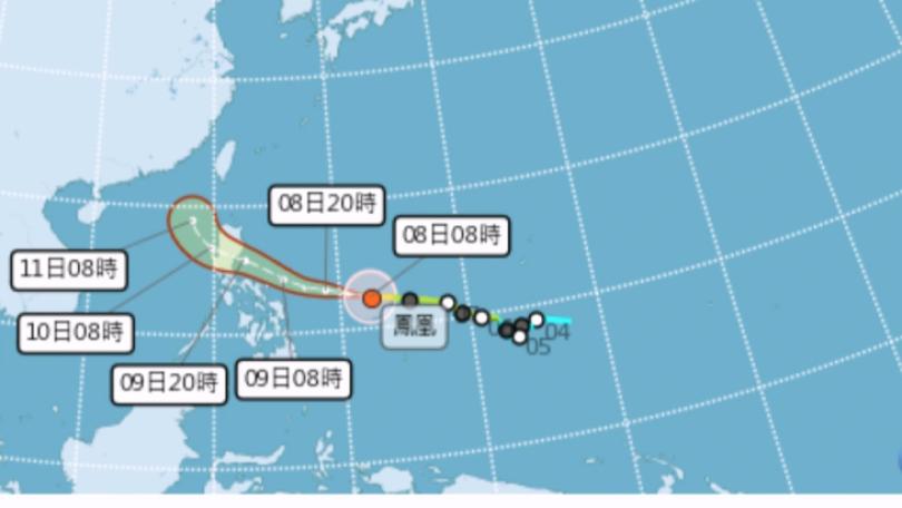
從氣象局的衛星雲圖可以清楚看見,強颱軒嵐諾的暴風圈正在壯大,目前它的位置來到台灣的東南方大約460公里的海面上,根據氣象局觀測,過去一段時間,南側的熱帶性低氣壓雲系漸漸併入軒嵐諾的環流中,預計未來它的暴風半徑和強度都還有增強趨勢,2日不排除就會發布海上颱風警報。
氣象局預報員謝佩芸表示:「以目前這個路徑,跟暴風半徑來預估的話,還是不排除明天有發布海上颱風警報的可能性,如果颱風有再更為偏西,或颱風的暴風半徑有再更為擴大,也依然不排除陸上颱風警報的可能性。」
氣象局表示,雖然軒嵐諾的颱風眼位置離台灣還有一段距離,但在外圍環流的影響下,北台灣已有間歇降雨,入夜後北台灣降雨越明顯,其他地區則是以午後雷陣雨為主,且今天開始到2日的上半天,颱風將進入導引氣流較不明顯區域,會在台灣東南方海面滯留,要到後天受到下一個導引氣流影響才會逐漸北上,週五到週日會是颱風影響台灣最明顯的時候。
天氣風險公司總經理彭啟明表示:「北部、東北部開始都會有顯著的雨勢,其實上從昨天開始,一直到現在為止,禮拜五到禮拜六這兩天,是雨最大的時候。」
另外在軒嵐諾颱風的影響下,台南以北與宜花地區有可能出現9到10級的強陣風,但是否會達到颱風假的標準,氣象局表示仍要由地方政府來決定。