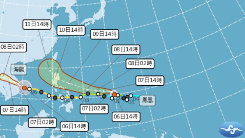
TYPHOON HAIMA CAUSES HIGH WAVES IN TAITUNG|颱風外圍環流影響 花東.南部防大雨
加入公視會員,
按讚收藏你關注的報導
發布時間:
更新時間:
Although Typhoon Haima spared Taiwan, air circulation at its outer edge has brought strong waves on the east coast, with waves reaching 3 meters high in Taitung. Also, intermittent rains in Downtown Taitung has again caused flooding at The famous Wuling Green Tunnel. The Central Weather Bureau has issued heavy rain warnings in 6 cities and counties, including Pingtung and Taitung today. Please take necessary precautions if you happen to be in those areas. And, don't let the rain get to you.
While Typhoon Haima did not make a landfall in Taiwan, the air circulation at its outer edge has triggered waves as high as three meters in Taitung. At the Xinlan Fishing Port, huge waves engulfed the lighthouse at one point.
==RESIDENT==
We have huge waves when there's a typhoon.
Strong waves were also observed on Orchid Island and Green Island. Green Island ferries have suspended operations until Oct 21. Downtown Taitung has also had some rain. The Wuling Green Tunnel was just flooded by Typhoon Aere on the 7th. Now the same thing happened again. Many roads in the mountains of Taitung were covered in water due to torrential rains.
Strong winds of category 8 to 9 were recorded in Hengchuen, Pingtung County. At the Zhongshan Fishing Port, fishing boats were docked inside the port to avoid strong winds. Rafts were overturned by waves. People even reported seeing waterspouts in Kenting. Ferries traveling between Donggang and Xiaoliuqiu have also been suspended due to strong gusts and waves.
==CHU MEI-LIN, Weather forecaster==
East and south Taiwan will continue to see lots of rain, with the possibility of torrential rains in some areas.
The Central Weather Bureau has issued heavy rain alerts in 6 cities. In the eastern and southern parts of Taiwan, the weather may remain unstable in the next two days. Taitung, Pingtung, and Hualien are expected to see the heaviest rains, so people are advised to bring their rain gear when leaving the house.
TRANSLATED BY:CHRISTINA LIU
一陣一陣的長浪打在防坡堤上,激起近3公尺浪花,海馬颱風雖然沒過境台灣,但外圍環流威力不小,台東外海一波波巨浪,新蘭漁港外海還可看到碼頭邊紅色指揮塔,一度被大浪吞噬,岸邊觀浪民眾也驚呼連連。
==民眾==
這裡每次颱風來 都會浪打得很高
離島的蘭嶼和綠島,同樣風浪增強,綠島交通船已提早宣布停航至21日;台東市區凌晨下起間歇雨勢,知名的綠色隧道,7號才因艾利颱風大淹水,現在海馬外圍環流又導致二度淹水,車子只能勉強行進在泥水當中,台東山區更因劇烈降雨,已經有不少路段,被水淹沒。
屏東恆春則颳起8到9級強陣風,滿州鄉中山漁港,不少漁船在港內避風,還有膠筏被長浪掀翻,墾丁外海甚至出現水龍捲,民眾搶拍,而往返東港和小琉球的交通船,也因風浪太大,下午停航。
==氣象預報員 朱美霖==
在我們東部 東南部
還有南部地區的降雨是相當明顯
而且持續的 會有局部的大雨
或是豪雨 或是大豪雨的發生
氣象局下午針對屏東、台東等6縣市發布大豪雨特報。也提醒,今明兩天在東半部和南部地區,天氣不穩定,最劇烈降雨會在台東,屏東和花蓮,民眾外出攜帶雨具,小心強陣風和大雨。
記者 李曉儒 邱福財 台北報導