Taiwan Monitors Typhoon Mangkhut's Path|強颱山竹稍偏南 不排除明發海警


加入公視會員,
按讚收藏你關注的報導
發布時間:
更新時間:
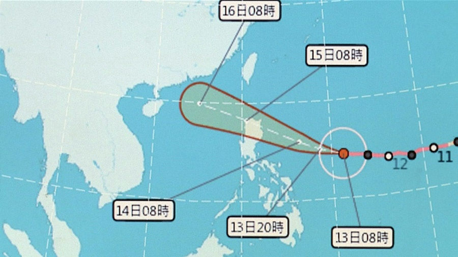
Super Typhoon Mangkhut is approaching Taiwan. The Central Weather Bureau predicts Taiwan's east coast will begin feeling the effects of the typhoon starting on the afternoon of Sept. 14. Although the typhoon's path has deviated slightly to the south, the CWB may still issue a sea warning on Sept. 14.
It can be seen from this map showing the Central Weather Bureau's predicted path of Super Typhoon Mangkhut that the typhoon's structure is very sturdy and its eye has enlarged. The CWB forecasts the typhoon will begin approaching eastern Taiwan on the afternoon of Sept. 14. The typhoon's path has deviated slightly to the south due to a strengthening Pacific high pressure system, but the CWB may still issue a sea warning.
When it approaches the waters off of the Philippines' east coast, the water temperature here will be more suitable. We can't rule out the typhoon strengthening and becoming this year's most powerful typhoon. Based on its current path, the Central Weather Bureau cannot rule out issuing a warning in the early hours or morning of tomorrow.
The bureau says the typhoon is traveling quickly and estimates it will continue moving in a northwesterly direction. Its center will pass over the northern end of Luzon and the Bashi Channel, and the storm-wind circle will sweep past the coastal waters of Hengchun peninsula. Forecasts from the United States military and NASA indicate the impact will be greatest on the northern part of Luzon. The Japan Meteorological Agency forecasts the center will pass over northern Luzon and then move towards southern China and Hong Kong. Although Taiwan won't bear the brunt of the storm, it will be affected by the periphery. There will be heavy rain in eastern and southern Taiwan.
The rain over the eastern side won't be like the torrential rain experienced by the north or the continuous torrential rain experienced by the south. The rain will last one to two days, but may be very heavy.
The CWB reminds the public that eastern Taiwan, Green Island, Orchid Island, Keelung's coast and Hengchun peninsula are already experiencing big waves. It is harder to predict the rainfall over western Taiwan, but the likelihood of high temperatures is high due to westerly winds. The air quality may also worsen.