Typhoon Megi will affect Taiwan for nest 2 days / 梅姬海警昨夜23:30發布 上午將發陸警


加入公視會員,
按讚收藏你關注的報導
發布時間:
更新時間:
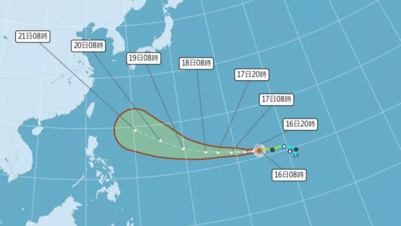
Moderate Typhoon Megi is moving closer to Taiwan and becoming stronger. In terms of storm radius, it is the largest typhoon to draw near Taiwan this year, and may cover the whole island. On Sept. 25 at 11:30 pm. the Central Weather Bureau issued a marine warning. This morning they may issue a land warning. Typhoon Megi is expected to make landfall in southeastern Taiwan and will have the greatest impact on Taiwan from Tuesday to Wednesday morning and the whole island will need to take typhoon precautions.
Typhoon Megi is advancing on Taiwan. On Sept. 25, extra ferries between Taitung and Green and Orchid Islands were put on for thousands of visitors and locals to return or leave before the typhoon.
==VISITOR==
Lots of people were sick, (Did it affect you getting back?) No. (Did the wind affect you?) I was afraid of the typhoon, so came back early.
The moderate typhoon is continuing to strengthen. It is currently located over sea, 230 kilometers to the southeast of Hualien, moving towards Taiwan at 21 kilometers an hour west-northwest. The CWB says it issued a marine warning on Sept 25 at 11:30 pm and in the morning of Sept 26 will probably issue a land warning.
==LUO YA-YING Central Weather Bureau technician==
It will remain traveling west-northwest towards Taiwan. There is a marine typhoon warning for seas to the east and southeast of Taiwan and this extends to the whole of the eastern sea area and the Bashi Channel.
The typhoon may make landfall on the southeast coast of Taiwan and from Monday morning the whole island will be affected by the outer storm radius. The north and east will be affected by intermittent rain showers.
==LUO YA-YING Central Weather Bureau technician==
After Typhoon Megi passes through Taiwan it will enter China. Taiwan will be affected by the storm radius and northern and eastern areas will bear the brunt of the wind and will have intermittent showers.
Currently the sea temperature is conducive to the further development of the typhoon and it may grow to almost strong typhoon status. The public should take measures against heavy rain and strong winds. On Tuesday morning the storm radius will be over land and will have its strongest impact. On Wednesday, it will gradually leave.
TRANSLATED BY:CLARE LEAR
梅姬颱風來勢洶洶,行駛台東和綠島,蘭嶼之間的客輪,昨天加開船班,疏運上千名遊客和鄉民。
==遊客==
好多人吐 (好多人吐)
(回來沒有影響) 沒有
(沒有被颱風影響)
害怕 害怕颱風
(趕快先回來)
中颱梅姬持續增強,目前位在花蓮東南方230公里的海面上,以每小時21公里速度朝西北西方向,向台灣陸地移動。氣象局已經在週日晚間11點半,發布海上颱風警報;最快週一上午,會再發布陸上颱風警報。
==氣象局氣象預報中心技正 羅雅尹==
未來會穩定朝西北西的方向
也就是往台灣的東部
到東南部近海前進當中
現在海上警戒區域的範圍
涵蓋整個東半部海面
以及巴士海峽
梅姬颱風不排除會從台灣東南部登陸。周一上午開始,全台都會受到颱風外圍環流影響,尤其迎風面的北部、東半部會有短暫陣雨。
==氣象局氣象預報中心技正 羅雅尹==
梅姬颱風通過台灣之後
會逐漸進入大陸地區
我們受到它外圍環流的影響
迎風面的北部 東半部地區
就開始會有間歇性的陣雨出現
目前海面條件,有利颱風發展,氣象局預測,中颱梅姬有機會發展到中度颱風的上限,要嚴防颱風造成的強風和強降雨;週二清晨暴風圈就會接觸陸地,是颱風影響最明顯的時刻,各地都會出現降雨,週三才會逐漸遠離,氣象局提醒大家,這兩天要做好防颱準備。
記者 綜合報導