TYPHOON MEGI MOVING IN FROM EAST TO COVER WHOLE ISLAND|梅姬暴風圈進入東部陸地 全台防強風豪雨


加入公視會員,
按讚收藏你關注的報導
發布時間:
更新時間:
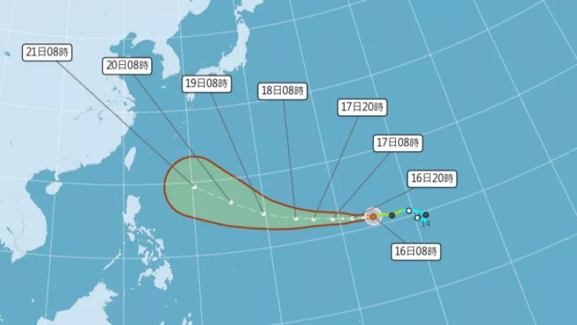
Typhoon Megi's storm periphery is currently making landfall this morning on the eastern half of the island. The eye will pass over Taiwan. All day today and until Wednesday morning, Taiwan will be impacted by the typhoon. The Central Weather Bureau says Typhoon Megi is similar to Typhoon Soudelor which was also big enough to cover the whole of Taiwan. The whole island will experience torrential rain
Typhoon Megi has continued to move towards the eastern half of Taiwan. The CWB says from early this morning the storm periphery made landfall and the eye will traverse Taiwan and Kinmen. All day today until Wednesday morning the typhoon will impact the whole of Taiwan.
==HSIEH MING-CHANG CWB 1ST DIV. 2ND SEC.CHIEF==
From Sept. 27 at 11 AM until Sept. 27 at 11PM all areas will experience heavy rain and the public must take precautions. The typhoon will gradually make landfall from the east so especially in the afternoon, there will be torrential rain in the east and other areas, there will also be very strong wind.
Typhoon Megi has continued to strengthen and the eye has become clearer. The storm radius has grown to 250 kilometers with force seven winds. The CWB says it is very similar to last years Typhoon Soudelor, having a huge storm radius and being very powerful.
==PENG CHI-MING private weather forecast company==
The winds on the northern periphery of this typhoon are very strong, the water vapor is to the south and moving in all directions. This typhoon is not completely structured, so once its storm periphery completely covers the island, there will be continuous rain and wind, so the public should think of this one as if its Soudelor.
Analysts say although the eye made landfall from the east, the huge extent of the storm radius will bring strong wind and torrential rain to northern Taiwan.
TRANSLATED BY:CLARE LEAR
梅姬颱風持續朝台灣東半部接近,氣象局預估,今天清晨,颱風暴風圈將觸碰到台灣陸地,中心將通過陸地後朝金門前進。今天一整天到週三上午將是颱風影響台灣最明顯的時候。
==氣象局第一組第二科科長 謝明昌==
27號11點一直到
晚上11點這段期間
各地整個下雨的狀況
都會明顯增強 要特別注意
在這段過程當中
正好是颱風要逐漸從東部這個地方
來進入陸地
所以特別在下午這段期間
除了下雨在東半部地區
非常明顯之外
風力也是最強的時候
梅姬颱風在行進過程中,強度還在持續增強,颱風眼清晰可見,七級風暴風半徑已經發展到250公里,氣象專家分析,梅姬颱風和去年為台灣帶來嚴重災害的蘇迪勒颱風一樣,都是暴風半徑範圍很大的颱風,威力不容小覷。
==民間氣象公司業者 彭啟明==
這個颱風它北邊北側風很大
水氣在南邊還有四周
其實它等於說 這個颱風可能
不是一個完全很對稱的颱風
所以它等到暴風圈
完全籠罩的時候
有時候風 有時候雨 都會接續著
造成很大的一個影響
所以我建議大家要用這種
蘇迪勒等級的應對
專家分析,雖然颱風中心將由東南部登陸,但寬廣的外圍環流也會讓北台灣風強雨大,提醒全台的民眾都要做好防颱準備。
記者 綜合報導