Typhoon Megi upgrades, will enter Taiwan from east / 梅姬已轉為中颱 預估從台東登陸


加入公視會員,
按讚收藏你關注的報導
發布時間:
更新時間:
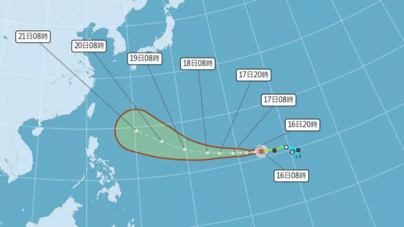
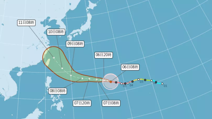
Tropical storm Megi upgraded to a typhoon on Saturday afternoon. It is expected to make landfall in eastern Taiwan in a few days. Starting Monday, the eastern half and northern parts of the island will be impacted by the outer system of the typhoon. On Tuesday and Wednesday, its impact will be the greatest. If it picks up speed later today, a sea warning may be issued by the Central Weather Bureau.
Take advantage of the good weather today, because from tomorrow the weather will change. The 17th western pacific typhoon of the year, Typhoon Megi, became a moderate typhoon yesterday. From Monday it's peripheral cloud system will begin to affect the northern and eastern half of the island. The Central Weather Bureau was to issue a marine warning early on Monday morning, but this may be brought forward by a few hours to this evening.
==LIN DING-YI Central Weather Bureau forecaster==
The CWB was going to issue a marine warning early on Monday morning, however, if its storm radius expands and it moves faster we may issue the warning on Sunday night.
A land warning for the typhoon may be issued on the afternoon of Sept. 26. From Sept. 27 to 28, Typhoon Megi will have the clearest impact on Taiwan. The CWB said from the current status, it looks as though the typhoon's eye will make landfall on eastern Taiwan. As the storm's radius increases, it looks as though it may strengthen and become a strong typhoon.
==LIN DING-YI Central Weather Bureau forecaster==
Because the surface of the sea it is traveling over is comparatively warm and vertical wind shear is relatively small
it is conducive to developing further to above moderate typhoon status, close to strong typhoon status.
From Sept. 26 to 28, due to the typhoon, flights from Taitung to Green Island and Orchid Island will be suspended. These will be resumed once when the typhoon moves away.
TRANSLATED BY:CLARE LEAR
第17號颱風梅姬,在昨天下午轉為「中度颱風」,預估接下來路徑,將從台東登陸。週一開始,東半部和北部會受「外圍環流」影響,週二、週三,影響最大 。最快在今天晚上,就會發布「海上颱風警報」。
不少民眾把握週末好天氣,在公園做運動,或是外出踏青,因為下個禮拜、就要變天。第十七號颱風梅姬來勢洶洶,直撲台灣而來。外圍雲系將在下週一開始影響東半部及北部天氣。氣象局原預計在週一清晨發布海上颱風警報,現在可能提前。
==氣象局預報員 林定宜==
氣象局預估在星期一的清晨
可能會對這個颱風
發布海上颱風警報
不過如果這個颱風
它的暴風圈有擴大
而且它的速度有增快趨勢的話
(海警)可能會提早到
星期日的晚上
陸上警報則預計在下週一中午發布,而梅姬27號到28號上午影響台灣最劇。氣象局表示,就目前資料研判,颱風中心可能會從台東登陸。隨著颱風的暴風圈範圍、強度還在持續增加,恐怕會到強颱的下限,到時侵台威力,不容小覷。
==氣象局預報員 林定宜==
因為它所經過的海面的
海水熱含量是比較高的
而且垂直風切是比較偏小的
所以是有利於它未來繼續發展
所以未來它可能會繼續成為
一個中颱以上的颱風
甚至接近中颱上限強度的颱風
受到颱風影響,26號到28號,台東往返綠島、蘭嶼的船班確定停開,將視颱風離開後的情況,再決定何時恢復正常,而民眾也要儘早做好防颱準備。
王柏文 蔣龍祥 台北報導