TYPHOON MERANTI HEADS FOR FUJIAN, TYPHOON MALAKAS MOVES NORTH|莫蘭蒂剛走 馬勒卡尾隨今夜恐發海警


加入公視會員,
按讚收藏你關注的報導
發布時間:
更新時間:
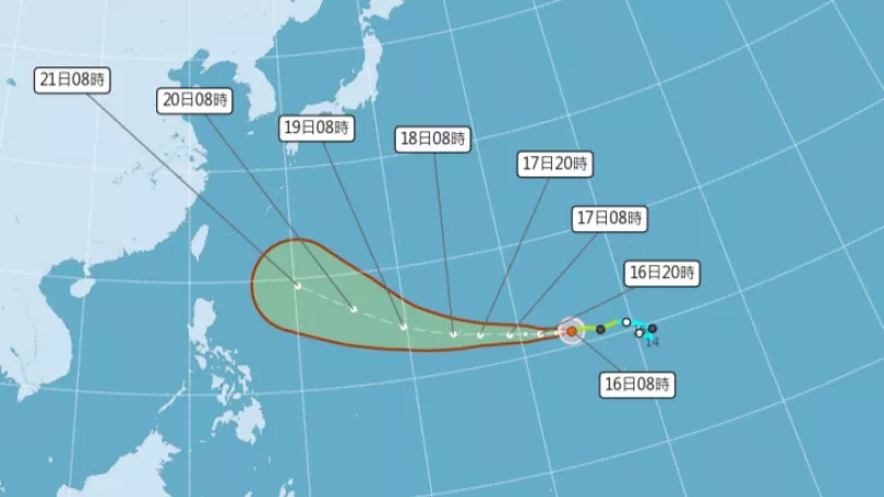
Land warnings for Typhoon Meranti were lifted at around 2 am this morning. The storm radius left Taiwan as it entered China's Fujian Province passing over Jinmen. Jinmen and Penghu are still experiencing heavy wind and rain. Hot on the heels of Meranti comes Tropical storm Malakas, which upgraded to a moderate typhoon yesterday afternoon. Marine warnings for Malakas may be issued any time from tonight to early Friday morning.
This morning at around 2 am land warnings were lifted after Meranti left a trail of destruction across the Hengchun Peninsula and brought strong winds and high seas. The eye was located at 30 kilometers west north west of Jinmen and is traveling north northwest. The Central Weather Bureau warned that the outer weather system would continue to bring heavy rain to southern Taiwan.
==HSIEH MING-CHANG Central Weather Bureau First Division, 2nd Sec.==
It will continue to weaken and the storm radius will continue to shrink however, before midday, the out edge of the system will impact areas to the south of Hualien and to the south of Taichung with heavy localised rain and there will be strong gusts of wind.
Meranti brought heavy volumes of rainfall. From Sept. 13 to 15, at 4 am, the eastern half of the island and Pingtung mountain areas all experienced 600 millimeters of rain. The places with the heaviest rainfall were : Pingtung County Xidawu Mountain with 829 millimeters, Hualien County Tianhsiang with 664 millimeters and Taitung's Jinjhen Mountain with 659 millimeters.
==HSIEH MING-CHANG Central Weather Bureau First Division, 2nd Sec.==
As the typhoon gradually moves to the northwest the cloud system will move northwards to affect Tainan and Kaohsiung and mountain areas in central Taiwan and in those areas there will be heavy rain and strong winds.
According to various weather organisations' predictions, moderate Typhoon Malakas will impact northern Taiwan.
==PENG CHI-MING Weatherrisk==
From European estimates it will probably be closest to Taiwan on Sept. 17 and 18. Assuming this route, the storm radius will pass over northern Taiwan.
The CWB may issue marine warnings for Malakas tonight or early tomorrow morning. On Saturday they may issue a land warning and northern Taiwan will experience heavy rain. Its going to be a rainy Mid Autumn Festival in Taiwan, no matter where you are.
TRANSLATED BY:CLARE LEAR
恆春民宅,屋頂被強陣風吹到只剩一半,台東外海也掀起11級大浪,莫蘭蒂颱風昨晚轉為中颱,今天凌晨兩點左右,本島解除陸警,颱風中心位置在金門的西北西方約30公里處,繼續朝北北西轉北方向行進,氣象局提醒因為外圍雲系的影響,南部地區還是不能掉以輕心。
==氣象局第一組第二科科長 謝明昌==
未來它將持續地減弱
暴風半徑也有繼續縮小的趨勢
不過在上午之前
可能還是會受到一些
外圍雲系的影響
對花蓮以南
以及台中以南的地區
可能都有機會帶來局部性大雨
有時候陣風還會稍微強一點
風強大浪,莫蘭蒂也帶來可觀雨量,主要降雨帶的東半部與屏東山區,13號到15號清晨四點,都下了超過600毫米,降雨量前三名分別是屏東縣西大武山829毫米、花蓮縣天祥664毫米,台東縣金針山659毫米。
==氣象局第一組第二科科長 謝明昌==
隨著颱風慢慢向西北移動之後
整個雲帶有逐漸向北移動
影響台南高雄
甚至中部的山區
這邊會出現比較強的降雨
才剛脫離莫蘭蒂的暴風圈,編號第16號颱風的馬勒卡,昨天下午兩點增加為中度颱風,氣象專家指出,按目前各國預測路徑來看,威脅北台灣的機會大增。
==天氣風險管理公司總經理 彭啟明==
如果現在從歐洲的預報模式
可以看得出來它很有可能是
在禮拜六的時候
到禮拜天的時候
影響非常接近到台灣
如果按照歐洲的路徑預測的話
它非常有可能暴風圈
就會掃過北台灣
馬勒卡接著來,氣象局不排除今天深夜或明天清晨,發布海上警報,假若週六接著發陸警,北台灣轉有雨,這個中秋假期,台灣民眾絕大多數時候,恐怕得在風雨中度過。
記者 綜合報導