Typhoon Chanthu likely to reach Taiwan on September 11 氣象局預估璨樹極可能侵台 於週六下半天登陸
加入公視會員,
按讚收藏你關注的報導
Chanthu is "very likely" to end Taiwan's streak of having no typhoon during the last few years.
Presenter: Typhoon Chanthu is very likely to become one of the few strong typhoons that hit Taiwan directly. It will be closest to the island over the weekend. Some experts say they see similarities between Typhoon Chanthu and Super typhoon Nepartak in 2016, which caused one death and a loss of nearly NT$ 100 million.
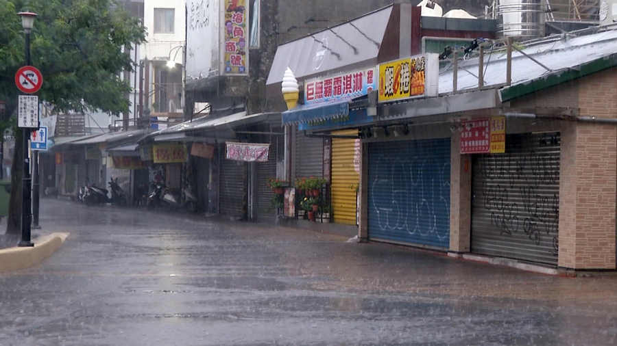
Two whale-watching ships take advantage of the good weather on the 10th to set sail, ahead of the arrival of Typhoon Chanthu.
Chiu Hsi-tung, Whale-watching Tour Operator:”We won't be able to go out to sea starting this afternoon, and probably not tomorrow or the day after either.”
The Central Weather Bureau issued a sea typhoon warning at 5:30 a.m. on the 10th. Whether Chanthu will strike Taiwan directly is still uncertain.
Hsu Chung-yi, Forecaster, Central Weather Bureau:”Its forecasted route has not changed and we expect to issue both sea and land typhoon warnings later today. Eastern, northern and southern Taiwan will be affected the most.”
The bureau says it will issue a land warning 18 hours before the typhoon makes landfall. Chanthu will be closest to Taiwan on the 11th and 12th, affecting eastern, northern, and parts of southern Taiwan. Very few typhoons have hit Taiwan directly in the last few years. The last one to get so close was Typhoon Nepartak in 2016, which caused agricultural losses of NT$960 million.
Peng Chi-ming, CEO, Weatherrisk:”We haven't seen such a strong typhoon coming towards Taiwan in a very long time. It may weaken as it gets closer to Taiwan, but it will still be at least a medium-strength typhoon.”
Based on Chanthu's current path, it will make landfall somewhere between Yilan or Hualien. Chanthu's storm circle will encircle all of Taiwan, with heavy rain forecasted islandwide especially in eastern Taiwan. Work and classes may be suspended on the 12th in eastern and northern Taiwan
週五一早風和日麗、艷陽高照,花蓮港兩艘賞鯨船,趁著好天氣,"璨樹"颱風入境前出港,10號下午就不再出海,準備綁船固定防颱作業。
賞鯨船業者 邱錫棟:「今天我們預計下午的航班,可能就開始做停航的動作。那明後天兩天那基本上也是在停航的狀態。」
10號清晨5點30分,中央氣象局發布海上颱風警報,至於颱風是否登陸,變數仍大。
中央氣象局預報員 徐仲毅:「就是預報路徑沒有變數,我們預計在今天的下午到晚間有可能發布陸上的,海上陸上颱風警報影響比較大的區域,大概是我們東半部北部地區跟南部的部份地區,會受到比較大的影響。」
氣象局表示,可在颱風登陸前18個小時,就預警性發布"陸警",預估週六及12號週日最靠近台灣。主要影響範圍東半部、北部及部分南部地區。氣象專家表示,近幾年來已經很少有強颱侵襲台灣,最近一次強颱,是2016年尼伯特颱風,當時造成農作物損失超過9.6億。這次璨樹如果登陸,強大風雨對台影響大。
天氣風險管理公司 彭啟明:「我們很久沒有經歷過一個強烈颱風侵襲台灣,當然它接近台灣的時候,有可能會稍微減弱一點點,大概是中颱上限接近強颱的下限這樣的一個幅度。」
氣象專家表示,預估璨樹路徑,會貼著台灣東部外海走,依照過去經驗,只要接近東部外海,環流受地形,特別是中央山脈,產生交互作用,屆時可能在花蓮,或往北一點宜蘭附近登陸,基本上全台,都有機會被暴風圈籠罩,有顯著降雨,東半部首當其衝,預估六日影響最大,預估週日,東半部地區、及北部地區有停班停課機率。