Typhoon Sarika to affect east and Hengchun / 莎莉佳撲台機率低 東部.恆春今晚變天

加入公視會員,
按讚收藏你關注的報導
發布時間:
更新時間:
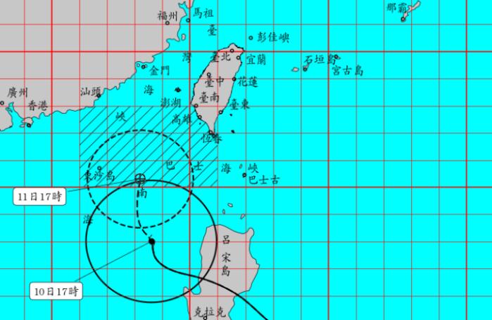
This year's 21st typhoon, Typhoon Sarika, passed through Luzon island last night, and caused one death and three missing. However, another tropical storm Haima is forming, with its strength and perimeter increasing by the hour. The Central Weather Bureau said that Typhoon Haima is currently 2,800 kilometers off the Cape Eluanbi and will not affect Taiwan until next Thursday.
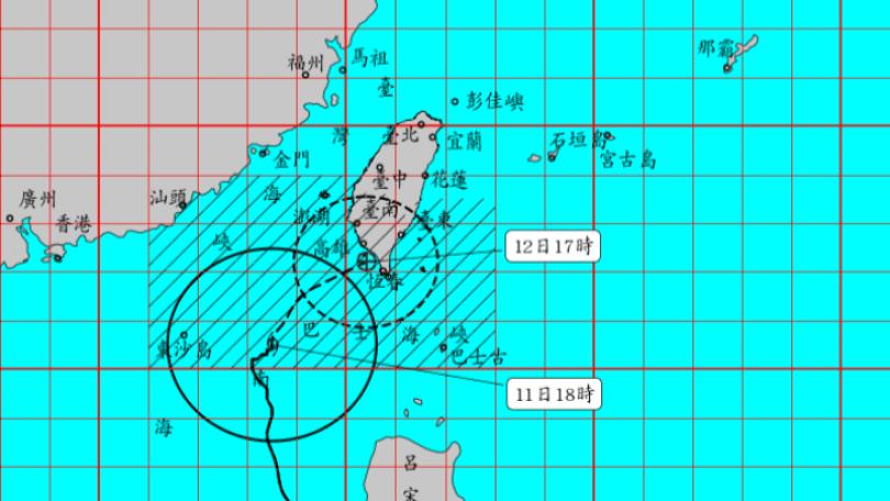
Taipei finally enjoyed a sunny day on Oct 15 after continuous rains that lasted over a week. The Central Weather Bureau said that the weather will also be sunny or partly cloudy all over Taiwan on Oct 16. Temperatures may even exceed 34℃ in western Taiwan. However, moderate typhoon Sarika will start affecting eastern Taiwan and the Hengchun Peninsula.
==HSU CHUNG-YI, Forecaster==
Starting on Oct 16 to 18, the cloud system on the outer edge of the typhoon will affect Taiwan's weather. Particularly, the eastern region and the Hengchun Peninsula may experience thundershowers.
The Central Weather Bureau said that Typhoon Sarika will pass through the Luzon island and enter the South China Sea tomorrow and will not make landfall in Taiwan. However, a mild typhoon, Haima will arrive right afterward. Typhoon Haima is currently still at sea, 2,800 southeast of the Cape Eluanbi, and moving west north-west at 20 km/hr. It is expected to affect Taiwan's weather next Thursday.
==HSU CHUNG-YI, Forecaster==
On Oct 20 and 21, Taiwan may be affected by the air circulation on its outer edge. Its strength is still growing and may develop into a moderate or even severe typhoon.
The cloud system at the outer edge of the typhoon will bring some rainfall in the northeast, north, and south Taiwan. Other regions may see some afternoon thundershowers.
TRANSLATED BY:CHRISTINA LIU
今年第21號颱風莎莉佳,預計今晚就會穿越呂宋島進入南海,侵台機率低,不過緊跟在後面的輕度颱風海馬,強度和暴風半徑持續增強,氣象局表示,海馬目前位在鵝鑾鼻東南方2800公里海面上,預估下周四才會影響台灣天氣。
連續下了一個多禮拜的雨,台北下午終於陽光露臉,不少人趁著好天氣出來逛街透透氣,氣象局表示,明天周日水氣減少、降雨趨緩,全台各地都是多雲到晴的好天氣,西半部地區甚至有機會出現34度高溫,不過好天氣只維持一天,到了周日晚上,受到中度颱風莎莉佳影響,東半部及恆春半島就要開始變天了。
==氣象局預報員 徐仲毅==
明天晚上開始一直到禮拜二
它的外圍雲系就會影響到
我們台灣地區的天氣
那主要影響的區域是
我們的東半部地區跟恆春半島
在我們的東半部地區
跟恆春半島
有局部大雨發生的機率
氣象局表示,中颱莎莉佳今晚到明天、將穿越呂宋島後進入南海,侵台機率低,不過緊跟在後面的另一個輕度颱風海馬,上午形成,目前位在鵝鑾鼻東南方2800公里海面上,以時速20公里、向西北西移動,預估下周四會影響台灣天氣。
==氣象局預報員 徐仲毅==
禮拜四 禮拜五這兩天
會是它外圍環流
外圍雲系所影響的時間點
至於它的強度在這段時間呢
是有利於它持續發展的
它的強度上
不排除到達中度颱風
甚至強烈颱風的可能
從下周一開始,受到颱風外圍環流雲系影響,東半部地區會出現局部大雨,北部、南部也有陣雨,其他地區午後則是有局部短暫陣雨發生機會。
記者 賴淑敏 蔣龍祥 台北報導